
 First you need to find {CFrequirment} Caches to create a new GeoPath
|
North Dartmoor Geopath | ||
|
|
|||
| GeoPath details | |||
| Mentor (?) |
Dartmoor Dave | ||
| Completed | 3 times | ||
| Scoring | 228.6 Points | ||
| Number of caches | 26 (0 / 0 / 0) | ||
| % cache finds required to complete GeoPath | 88% ( Geocaches) | ||
| GeoPath type | Touristic | ||
| Publication date | 01-06-2021 | ||
| Owners | Dartmoor Dave | ||
| GeoPath's description | |||

North Dartmoor GeoPath
For more details, interactive map and useful downloads, please click here: North Dartmoor GeoPath
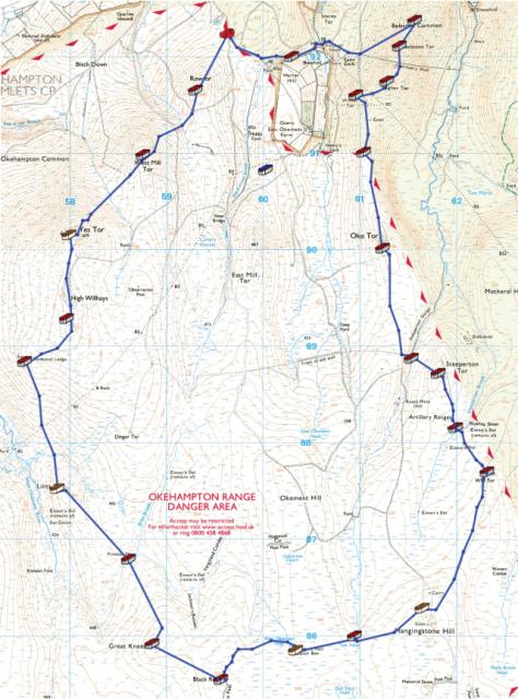
The North Dartmoor GeoPath is the first GeoPath in the UK. It will take you on a tour of many of Dartmoor's most striking and characteristic locations including High Willhays, the highest point in England south of the Peak District; Black Ridge, the most remote point in the UK south of Northumberland and of course the famous Cranmere Pool letterbox, the first ever letterbox.
This GeoPath consists of 23 traditional caches, 1 puzzle cache and 2 moving caches. To complete the GeoPath you will need to find 23 of these 26 caches. Of the 26 caches, 21 are new caches and 5 are existing caches.
The total length of the GeoPath is just under 13 miles, but any deviation from the route to find additional caches will clearly increase that. The GeoPath has been designed to be completed in a single day, but that of course is a matter of choice and you may take as many days as you wish and choose whatever route you wish. All caches have been hidden to be found and spoiler photos and/or hints are available for every cache. Ensure that you print spoiler photos before you start or download them from the Dartmoor Geocaching web site, as often there will be no mobile phone signal along the route.
The GeoPath was designed to be completed in an anti-clockwise direction and any directions and waypoints, etc. included in the cache descriptions will assume that direction of travel. The majority of the route is on good paths but the Army tracks have been specifically avoided. However, these tracks would be extremely useful to anybody who decided not to complete the GeoPath on a single day, as they can be much quicker to get you to or from a more remote point on the route. It is worth noting that some of the paths used are not shown on either the OS map or the OSM map. In some places there will not be any path and it will be a case of "following the arrow".
There are no major river crossings anywhere on the route, but even the smallest streams can swell quickly after heavy rainfall. Where possible I have included waypoints to assist navigation and indicate the best crossing points for these streams.
Bonus Information
There are 8 pieces of bonus information to be collected on the GeoPath. Each piece of information is repeated and no bonus information is included in the existing 5 caches. This is to prevent those who have already found the existing caches from having to re-visit them.
Once all 8 pieces of bonus information have been collected it is an easy calculation to determine the location of the bonus cache, which will be easier to reach if the GeoPath is completed in the anti-clockwise direction indicated.
Moving Caches
There are 2 Moving caches somewhere on the route. These contain the same bonus information in both, so at least one of them will need to be found. Moving caches are designed to be moved, so please do move one of them. Please place it on the same day and ensure that it remains within about 100 metres of the route shown. If possible please take a new spoiler photo. Please log the move within a day of it being moved so that others will know where it is. Full instructions on how to do this are on the cache page.
GeoKrets
There are also 2 GeoKrets on the route. These are trackables which can move from Opencache to Opencache, but please do NOT place them in GC caches. These also contain the same bonus information on both, so again at least one of them will need to be found. Please do move one of them to another Opencache included within the GeoPath and please log that you have moved it within a day.
Completion of GeoPath
The GeoPath has been completed when you have found 23 of the possible 26 caches, whether or not you have found the bonus cache. However, the bonus cache contains 6 unactivated Limited Edition Dartmoor Geocoins for the first 6 cachers to complete the GeoPath. PLEASE NOTE: These geocoins are prizes for completing the GeoPath and not just for finding the bonus cache.
SWAG
I have placed some good quality SWAG in many of these caches, which are aimed at adults. I know that few carry SWAG to swap so if you are attempting this geopath please feel take just one piece of SWAG on me.
IMPORTANT NOTE
This majority of this GeoPath is located within the Okehampton Military Range where live firing occurs. You must check out the Firing Notices before entering the range. DO NOT ENTER THE RANGE WHEN THE RED FLAGS ARE FLYING. Never pick up any objects, they may be unexploded devices.
The weather on Dartmoor can change suddenly and unexpectedly and ALL types of weather conditions can be experienced. Please ensure that you have the correct clothing and map & compass (and know how to use them). Please do NOT rely solely on your GPS or phone.
I would like to thank the Dartmoor National Park Authority for their kind permission to place the caches within this GeoPath, which have been placed according to the geocaching guidelines.
| Caches in this GeoPath North Dartmoor Geopath |

|


