

 Zaloguj się, by zobaczyć współrzędne.
 1x znaleziona
  0x nieznaleziona
  1 komentarze
  1 obserwatorów
  Oceniona jako: b.d.
 1 x rekomendowana


aby zobaczyć współrzędne oraz
mapę lokalizacji skrzynki
 Atrybuty skrzynki


 Opis
EN
Opis
EN
A puzzle that invites you to find information about Devonport Leat using whatever resources you can think of ") . The same puzzle is presented twice, with the same answers, but leads to two quite separate caches - this one, which is placed near the current end of the leat and is quite easy to get to, and another which is near West Dart Head and involves a long walk to the middle of the moor.
. The same puzzle is presented twice, with the same answers, but leads to two quite separate caches - this one, which is placed near the current end of the leat and is quite easy to get to, and another which is near West Dart Head and involves a long walk to the middle of the moor.
Devonport Leat was constructed in the 1790's with completion in 1802, to bring water from Dartmoor to the growing population of Devonport (which was called Plymouth Dock in those days). Plymouth already owned the rights to the water on the west of Dartmoor, so the new leat had to cross that part of the moor without taking water from it. The leat was a little under 40Km long when first built, but only about 26Km remains of it now.
I love Dartmoor and visit 2 or 3 times a year. I had often seen parts of the leat on my visits, and a few years ago drew up a plan to walk as much of the remaining length of it as possible in one day. It turned out that I was unable to follow one relatively short section because it was on private land, but we can still cross that section "virtually". It wasn't easy to correctly trace all of the route on maps, but once I was satisfied I had a route, I arranged to stay at Dartmoor Dave's hotel in the middle of Dartmoor. Dave and Judy got up early to cook my breakfast . I set off bright and early in the morning by the back door, and stepped from the back garden gate straight onto the moor.
There are 3 weirs at which river water is extracted into the leat. I started at the highest and furthest one, on the West Dart.
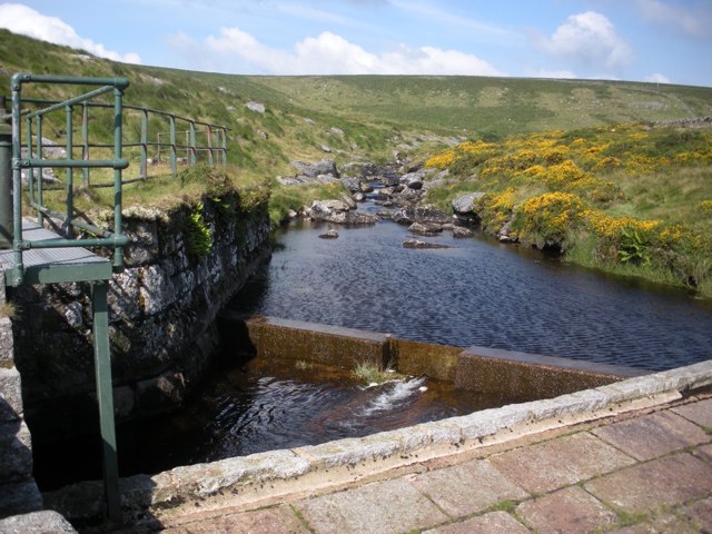
Locate the West Dart weir. Starting from the slope, how many steps up do you need to take to reach the weir platform shown in the photograph? This is A. Also make a note of the altitude for later.
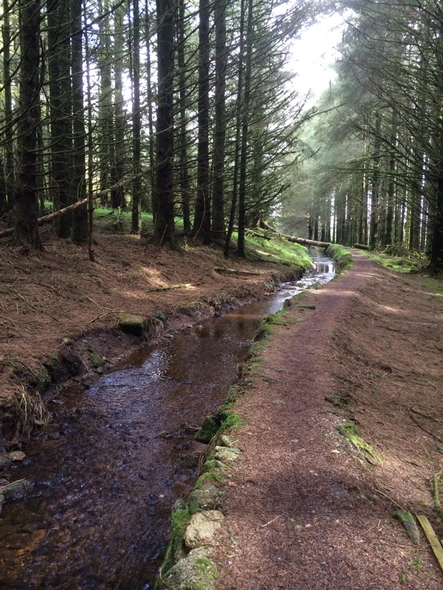
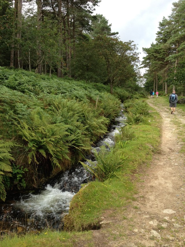
Follow the leat (not the river) as it follows the contours south on the flank of Beardown Tor. Above to our right is the rugged tor, and across the valley is the spooky but eerily beautiful Wistman's Wood. The leat is in excellent condition here, and the walking is easy - and with the great views it is a wonderful start to the walk.
The footpath from Beardown Tor to Two Bridges crosses the leat on a stone bridge, and the leat enters the forest on Beardown Hill.
The leat passes through the forest and under a farm track - but we will pause here and take a diversion to a second weir.
A second source of water for the leat was the Cowsic River.
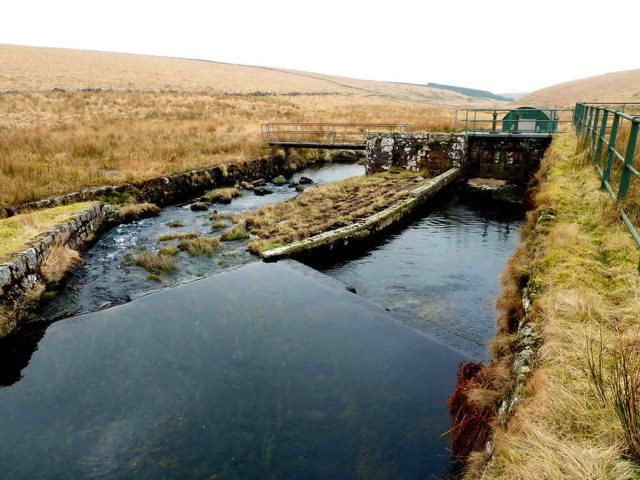
Locate the Cowsic weir and find its altitude. Round it to the nearest 100 metres and take the first digit as B.
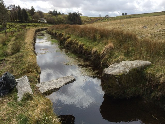
Now follow this branch of the leat southwards. After about 1.5Km it takes a turn to the east. And you may notice that we are now close to the point where we broke off from following the West Dart section - but that was on the north side of the Cowsic River valley and we are now on the south side.
When the leat was first constructed in the 1790's, water from the West Dart flowed up the east side of the Cowsic valley to the Cowsic weir, where the two sources joined. But this section required considerable maintenance and in 1899 a modification was made - the West Dart water was taken through a grating into a syphon (an 18 inch pipe), down the north side of the Cowsic valley and across the Cowsic river in an aqueduct.
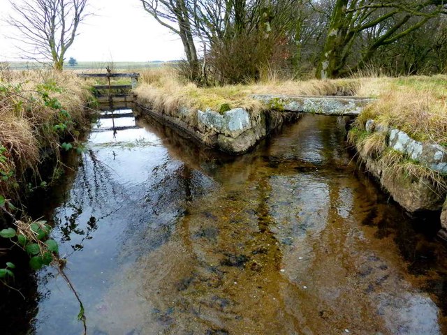
The pipe then ran back up on the south side, to discharge into the Cowsic arm of the leat by a fountain.
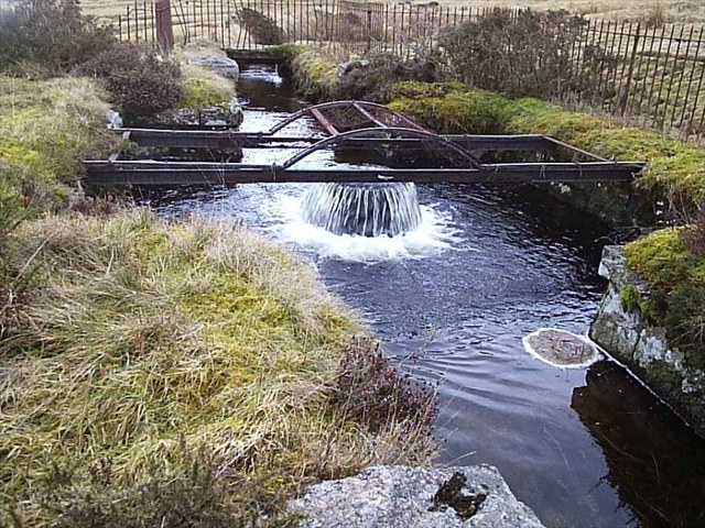
It is a fountain because the West Dart water has a greater head than the Cowsic water. Find the difference in head rounded to the nearest 10 metres and use the first digit as C.
The West Dart water disappears into the grating a little way west of the farm track. Find the distance between the grating and the fountain rounded to the nearest 100 metres and use the first digit as D.
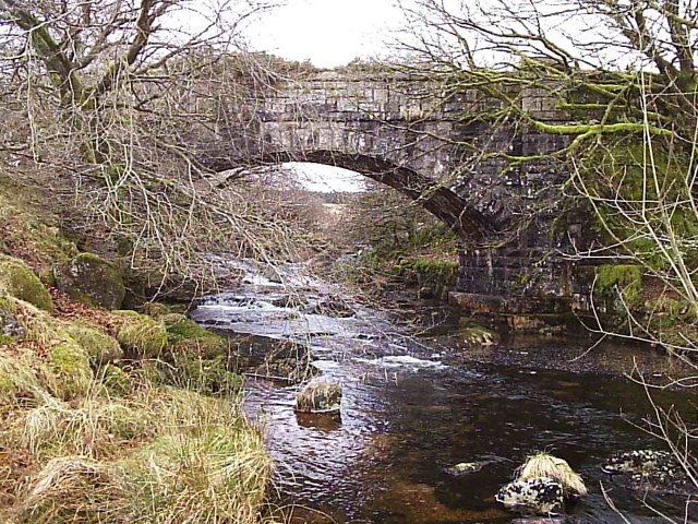
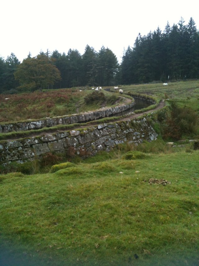
Continue downstream from the fountain. The leat passes under a road. The north side of the road has a low parapet with 2 rows of stones sticking up. EF is the number of stones in the row furthest from the road, not including the end stones.
The leat then follows the contour in a clockwise direction and heads towards Dartmoor Prison at Princetown. It crosses the Blackabrook River by an aqueduct - how many pairs of rows of rivets are there on this aqueduct? This is G.
The third and final source of water for the leat is the Blackabrook river that we have just crossed. The weir is a little way north of the aqueduct - how many sluice gates does it have? This is H.
The short Blackabrook Leat runs from this weir to where it merges with the Devonport Leat just north of the prison.
The combined waters then run south of the river until they cross another B road - what is the last digit of the road number? This is J. Unfortunately this section of the leat was in poor repair and clogged with weed on my walk.
From here there is a very pleasant but uneventful walk, generally southwards but with a clockwise loop around the hill at Peat Cot. The 2 projecting stones are a "sheep leap", to assist them crossing the leat without falling in.
My recollection is that there was a small but noisy private wind turbine at Peat Cot, but I can't see it on maps or on Google Earth. After this loop the leat passes under an unclassified road. How many stones comprise the top course on the NE side? This is K.
At Nunn's Cross the leat enters a tunnel. There is no access to the tunnel and a warning about a dangerous gas.
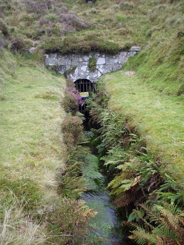
L is the number of letters in the name of the gas. M is the first digit of the length of the tunnel in metres.
On my walk I had to climb the hill over the top of the tunnel to find the exit, which is very slightly north of west. The leat then winds its way a little north west, where a bridge with an unusual name carries a track across the leat. N is the number of letters in the name, not including the word 'bridge'.
We then walk another 2Km or so until we reach the 4th footbridge after 'the bridge with the funny name'. Until now, the leat has followed the contours in the gentlest of descents, an amazing feat of surveying considering it was built in the 1790's. Find the altitude at this footbridge and subtract it from the altitude you recorded for the West Dart weir. When you consider just how far we have walked from West Dart weir, this is an astonishingly small number. The first digit of this number is P.
But as we approach the top of Raddick Hill, the character of the leat changes. In the next 1.25Km it loses 30m in height, then turns left and plunges down the side of the hill in a torrent, losing another 40m height in just 150m.
It passes across a river in an aqueduct - but the water in this river belonged to Plymouth, not to Devonport, so they had to be kept separate. How many letters in the name of this river (not counting the word 'river')? This is Q.
After crossing the aqueduct, the leat turns left and resumes its placid descent.
Soon it enters a beautiful and peaceful plantation.
It curves around the base of Leather Tor and passes a small cross before going under a road by the most innocuous of bridges.
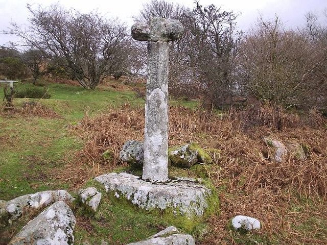
How many letters in the middle word of the name of this cross (it begins and ends with 'cross' and is not plural)? This is R.
The leat follows the road for a while, passing beneath it 3 times more as it nears the end of its journey.
And what an end it turns out to be! At the very end of the leat, some of the water is piped to a water treatment plant and the rest falls through a hole. After the most gentle and regulated life, other than a brief fling on Raddick Hill, it ends in an orgy of destruction. After entering the hole in the leat, the water is ejected at high speed into thin air above the reservoir.
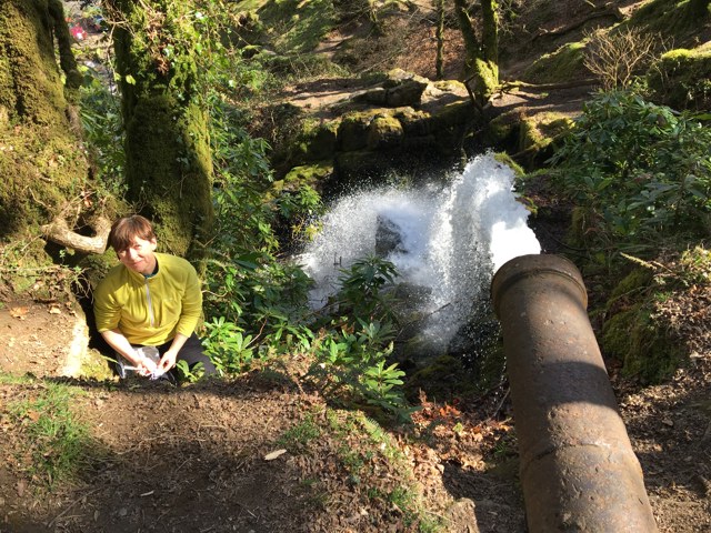
It plunges in an anarchistic cascade, bouncing off boulders, ricocheting off rocks, flinging spray high into the air.
And then it's all over.
Dartmoor Dave drove out to meet me and accompanied the last couple of Km of my walk. He took me back to the hotel where Judy had prepared a sumptuous meal and a bottle of wine for us.
A thoroughly enjoyable day, in every way - but now it is your turn.
You have one last piece of information to gather. Right where the leat passes under the road to enter the Burrator Reservoir, there is a telegraph pole with a single number on it - this number is S.
Now take the values for letters A-S that you have collected (letters I and O are not used) and enter them into the checker. If they are correct, it will give you the co-ordinates for the cache.
The hint and a spoiler is in the checker.
If your answers are not correct, and you would like some assistance, please let me know your answers AND how you obtained them. This is important, because if you have a different answer to me, and it was from a credible source, then I will need to amend the puzzle to resolve the ambiguity.
Acknowledgements to:
BrentorBoxer for the photos of the aqueduct across the Cowsic, the fountain, and the cross.
Gribben for the photo of the tunnel.
K. Ryan for the photos of Cowsic head weir and the confluence of the Blackabrook and Devonport Leats
DartmoorDave for the image of West Dart head weir.
 Wpisy do logu:
1x
0x
1x
Wpisy do logu:
1x
0x
1x


