

 Please log in to see the coordinates.

 Rated as: n/a


 Cache attributes


 Description
EN
Description
EN
Just east of Sedbergh is a major change of rock type where the Lake District and the Yorkshire Dales have crunched together. The change occurs along the Dent Fault, first identified by one of the 'fathers of geology' Adam Sedgwick, who was born nearby in Dent on 22nd March 1785.
Adam Sedgwick studied the rocks of the British Isles and Europe and was a pioneer of the science of geology. He founded the system for the classification of Cambrian rocks, and the order of the Carboniferous and underlying Devonian strata. Sedgwick investigated the phenomena of metamorphism and concretion, and was the first to distinguish clearly between stratification, jointing, and slaty cleavage.
Educated at Dent school and Sedbergh Grammar school, Sedgwick
went to Trinity College, Cambridge, where he graduated with a first
class honours in mathematics in 1808. However, it is as a geologist
that he is best remembered. In 1985 the Sedgwick
Geological Trail was created by the Yorkshire Dales
National Park and partners to celebrate the bicentenary of the
birth of Adam Sedgwick. The Trail explains the geology of the
Dent Fault, which is a major fracture in the earth's crust and
formed about 290 million years ago, during a period of mountain
building which pushed up the Caledonian mountain range. Rock
structures are often hard to see but here the river has exposed the
sequence of rocks.
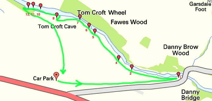
The text below is from a combination of sources and simplifies the Trail leaflet. For more detail the very informative Trail leaflet can be purchased from the Information Centre in Sedbergh. It costs £1 and has extensive notes and pictures. It's well worth investing in. The Trail is marked by numbered posts which are all still present - see the map pic and note the info about the later posts. The trail is on Longstone Common, starting at a popular car park giving a fine view of the Howgills. Watch for sheep and don't feed the ponies!
Overview: To the east is the Yorkshire
Dales. Many of the hills have a stepped profile, which
results from the repeating horizontal beds of shale, sandstone and
limestone. These sequences are underlain by the thick mass of
the Great Scar Limestone, responsible for the many fine cave
systems of the area. All these rocks are from the
Carboniferous period. To the west are the older rocks of the
Silurian period, the Windermere Supergroup of sedimentary rocks,
which form the southern Lake District and the Howgills. The
Dent Fault is the junction between these two areas. This is
the zone of movement where the edge of the Dales' limestone has
been 'crumpled' against the upthrusting Lake District during the
period of mountain building.
Trail Detail: The Sedgwick Geological Trail has twelve sites marked by numbered wooden posts. Start from the car park on the A684. A viewpoint info panel describes the view and gives some data about Adam Sedgwick. Walk down the minor road towards Danny Bridge, which spans the River Clough.
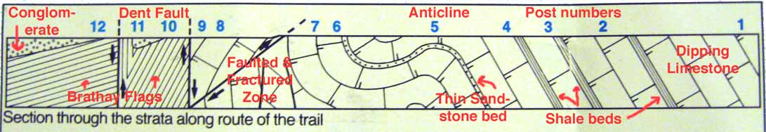
Site 1 is on the grass just downstream of the bridge, on the south side of the river. The river has cut a narrow gorge through the beds of Great Scar Limestone of the Lower Carboniferous, dating from about 330 million years ago (mya). The beds were laid down horizontally but have been tilted by the huge forces along the Fault. The beds dip down approximately 60 degrees upstream. The obvious bedding plane under the bridge shows this well. A small cave is in the bank by you. It’s a ‘resurgence’, which is where the water which has found its way through the beds and joints reappears at the surface. The river has chopped through the limestone exposing the cave and allowing the water out.
Site 2 has exposed fossils. Look for white marks in the water-washed rocks. Some are 10cm semi-circular forms, which are shellfish - Brachiopods. You may also be able to identify clusters of small tubes, which are coral colonies. Both indicate the shallow warm seas the limestone was formed in.
Site 3 The limestone beds are often separated by millimetre thin beds of shale showing that conditions were not stable. There had been short periods when muddy sediments were deposited. Either side of site 2 and 3 are three shale beds over 1m thick and fossil land plants suggest that these formed in coastal swamps as the sea level fluctuated. The shale is softer than the limestone so has been eroded out by the river to form deep gullies. Small bridges take the path over them.
Site 4 has several deposits of black Chert in the limestone possibly resulting from silicious gel settling on the sea bed. From the post go towards the river and the obvious tilted bedding plane has a black, very hard surface, which is the Chert, a variety of flint.
Site 5 Look at the opposite bank - instead of the limestone dipping, the beds appear to arch over. This upfold is known as an anticline. Just downstream, before site 6, you may be able to spot the rocks curving into a downfold or syncline. The rocks have been crumpled and folded by the movements in the crust.
Site 6 The beds here are dipping nearly vertically and about 5m upstream of the post is a 1m thick sandstone bed, carefully look over the side of the bank. Like the shale, conditions changed for a time. The graded particles suggest an advancing river delta on the Carboniferous coastline.
Site 7 Tom Croft Cave is fun to look in - a torch would be helpful. Go in the largest entrance - mind your head. At the back a small passage runs left, which you can climb into if you wish. Look at the cross-section of the passage. The top is thin and vertical where the water has eroded down through a joint. The middle then widens out into a circular cross-section. This was when the water table was high and the cave was full of water, so it eroded on all the surfaces equally, called Phreatic formation, creating a tube. The bottom of the passage becomes a vertical ‘canyon’ again. This was when the cave wasn’t full of water and a stream ran along the floor of the cave eating downwards, called Vadose. A lot of Yorkshire caves show these two types of cave formation. During the Ice Ages glaciers cut deep valleys and chopped through the lower cave systems, letting the water out. Vadose canyon passages continued to form, as well as stalactites from drips.
A smaller cave with a stream emerging is a few metres downstream of the two main cave entrances, close by the steps. Also look at the 'kettle holes' in the rocks by the river, ground out by swirling rocks, showing higher river levels. There are white mineral veins in the limestone, from the heat at the Fault, and the beds have been pushed vertically and fractured.
Site 8 gives a good view over the lower Trail. Notice the distinct difference in the width and shape of the river valley. Gone is the narrow limestone gorge. Directly in front of you in the gully is the Dent Fault. Go down the steps to the stile and you cross onto rocks at least 100 million years older than the limestone. Over the stile turn upstream to find post 9.
Site 9 is the upstream edge of the Fault. The limestone is obvious but it then turns into a mass of irregular fragments - a breccia. The rock has been shattered into small pieces by huge frictional forces along the Fault. There are mineral veins in the breccia from hot fluids created by the Fault movement, which have penetrated and condensed in the rocks.
Site 10 Head downstream across the Fault to post 10. Take care along here as there’s not much path in places - more erosion! Here you can see a fine-grained, slaty mudstone (Brathay Flags), deposited 425 mya and dipping downstream at 62 degrees, which has replaced the limestone.
The Brathay Flags are overlaid by a red pebble conclomerate. The conglomerate is about 50 million years younger than the Flags, and this ‘gap’ in the stratification (rock sequence) is called an unconformity. The conglomerate is made up of pebbles and contains Brathay Flags, so it must have been laid down in water and the Flags must have been exposed land surface at the time. The red colour probably comes from oxidization in a desert environment. It dates from the late Devonian or early Carboniferous before the land was submerged beneath the advancing limestone forming Carboniferous sea.
Site 11 shows a better outcrop of Brathay Flags, bedded vertically. Between 10 and 11 the Flags are folded beneath you with the conglomerate filling what became a small eroded valley, perhaps a desert wadi, now cut through by the river.
Site 12 can be tricky to reach as you have to climb round the promontory of Brathay Flags. Ahead, steps lead up onto the open common and the return to the car park. The furthest promontory shows the conglomerate very well. The Brathay Flags between 11 and 12 do yield fossils known as graptolites, small colonies of free floating organisms. These show that the mudstones were deposited in a deep ocean.
If you don’t want to climb round to site 12, simply return to site 8. If the river is in spate, don’t try to visit anything after site 8.
If you wish to "demonstrate that learning has taken place" at this earthcache you may like to provide the photos below and answer the questions. Email the answers through our profile if you wish to check you got them right.
- Please take a photo showing the anticline.
- Please take a photo at site 9 showing the edge of the Dent Fault, where the limestone turns into breccia.
- Identify the small cave downstream of the twin entrances to Tom Croft Cave, by the steps. Does it primarily show signs of Vadose or Phreatic cave formation?
- Which rock types found along the Trail were formed in the
following environments?
- Shallow, warm tropical sea
- Coastal swamps
- River delta
- Deep ocean
- Hot desert
Adam Sedgwick first understood the Dent Fault and his
explanations have held true even after another century of
geological study. His work is remembered in the Sedgwick Museum of Earth
Sciences in Cambridge, and through the Sedgwick Prize
encouraging the study of geology. The year after his death
the residents of Dent commissioned a large granite fountain on the main
street in Dent simply inscribed with his name. It stands
there today and it's worth visiting the old village. Charles
Darwin learned much about geology from Sedgwick and sent him rocks
while voyaging on the Beagle. Interestingly, despite doing so
much to promote understanding of geology and how the Earth was
formed, Sedgwick wasn't convinced by Darwin's ideas on evolution -
perhaps his only 'fault'?
We hope you enjoy your trip along the Sedgwick Trail to the Dent
Fault.
 Additional hints
 Log entries:
 1x
1x
 0x
0x
 0x
0x


