

 Zaloguj się, by zobaczyć współrzędne.
 4x znaleziona
  0x nieznaleziona
  0 komentarze
  0 obserwatorów
  Oceniona jako: b.d.


aby zobaczyć współrzędne oraz
mapę lokalizacji skrzynki
 Atrybuty skrzynki


 Opis
EN
Opis
EN
Although this is an 'other' type cache, it IS at the given co-ordinates!
To find the area, look for the brown road sign , which points the way to plenty of free hard standing parking, a viewing platform , small grassy area, picnic benches and information panels .
PLEASE NOTE :
This cache requires you type a keyword into the logging page to claim the find as well as signing the paper log.
The keyword is the first full word in bold in the left hand block of text on the left hand information board
(the board with general local history, not that of the battle)
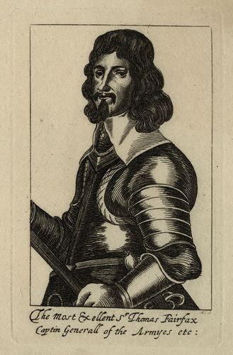
A foggy Saturday morning, the 14th of June 1645, and the two opposing armies are massed and ready for what will prove to be the decisive battle of the English Civil War . The Parliamentarian army under Fairfax, Ireton and (in a fairly minor role today) some bloke called Cromwell were here, being brought information from their scouts , planning , and waiting ...
Go to the platform for a mounted general's eye view and to find the keyword that you need..
At the windmilll rallying point, because of the lie of the land, Fairfax did not have a good view of the countryside between his army and that of the Royalists. Choosing where best to move his troops to was an absolutely vital step for his battle plan to succeed. We forget in these days of accurate maps and easy communications that a Civil War commander had to rely on sketchy mapping, help from local inhabitants,and the intelligence provided by risky scouting parties to deploy his forces in unfamiliar areas. So Fairfax with a small group moved up to near here to gain a better view at first hand.
The decision was made to shift the army from the very advantageous high ground where it was, which Prince Rupert was most unlikely to risk attacking , and down to the gentler hill to the north west where he might be tempted to join battle.
Good downloadable pdf battlefield maps and further information can be found here and here.
 Dodatkowe informacje
 Wpisy do logu:
4x
0x
0x
Wpisy do logu:
4x
0x
0x


