

Toon cache statistieken
Historic Britain: Caesar's Camp Iron Age Hill Fort (Offset) - OK01B8
The idea of the cache is to take you on a nice circular walk along the perimeter earthworks.
Eigenaar:
sandvika
 Log in om de coördinaten te kunnen zien.
 5x Gevonden
  1x Niet gevonden
  3 Opmerkingen
  0 Volgers
  Beoordeeld als: n/b


 Cache attributen


 Beschrijving
EN
Beschrijving
EN
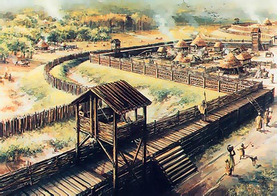
Caesar's Camp is said to be the best example of a true Iron Age contour fort in the country. The defences follow every valley so strictly, that the resulting plan resembles an oak leaf - clearly visible as such in Google Earth. Despite the name it is in fact the site of an Iron Age hill fort built between 2500-2700 years ago.
The closest available parking is at The Look Out Discovery Centre, Nine Mile Ride, 51° 23.250'N 0° 44.400'W which is an excellent place from which to explore the many caches in this forest.
The Site
Caesar's Camp occupies a natural spur of plateau gravel. A remarkable piece of engineering, constructed entirely by hand using basic tools, the hill fort covers an area of 7.2 hectares and is surrounded by a ditch. This ditch is almost a mile long, and was dug entirely by hand, with the waste material collected to form a bank on the inside.
There have been no major excavations of the hill fort, but English Heritage did a geophysical survey and small scale sample excavations which sadly revealed very little. The obvious use of a hill fort is as a defensive location, but it is possible that it could have been a market place or a religious or political centre. While the actual arrangement of buildings on the site is unknown, work on other sites has given us a good idea of what they would have looked like. Iron Age houses consisted of a circle of timber posts spaced 1-2m apart which supported rafters for the roof. The walls were made of wattle covered in daub, and perhaps lime-washed. The roof was probably thatched. Square or rectangular structures built with four posts would have been used as animal pens, granaries and sheds.
Recent Management
The remnants of the hill fort, the banks and ditches, have suffered from erosion by natural and human actions. Until recently, the interior of the hill fort was covered by a conifer plantation and the bank and ditch by deciduous trees. These prevented grass from growing on the site, which acts as a better protective barrier to erosion than other vegetation. Recent management work has sought to alleviate these problems through the thinning of trees and sowing of grass. The interior of the fort has also been cleared of trees, so that its full extent can now be seen, and sown with heathland plants, which used to cover the site according to drawings made during military exercises in the late eighteenth century. Since then, Berkshire has lost 97% of its heathland which has led to declining numbers in the plant and animal species it supports.
The work to protect Caesar’s Camp will benefit not simply the archaeology of the site, but also the ecology and environment. The heathland being restored on the interior of the fort will benefit rare ground-nesting heathland birds, such as Woodlarks, Nightjars and Dartford Warblers. To this end, please avoid bringing dogs into the site if you can, or else keep them on a lead at all times.
Please note that the hill fort is legally protected, and it is an offence to use metal detectors upon it or damage it in any way.
The Cache
The idea of the cache is to take you on a nice circular walk along the perimiter earthworks. Unfortunately the original highly informative information boards have been replaced with much poorer ones in different places and the cache has been reworked to allow most of the original route to be followed.
At the start coordinates, best approached from the East, you will find the perimeter fence and an information board describing the East Entracnce to the fort that lies in front of you. From this you need to establish the following:
1 - Iron Age society in the Ath Century BC was essentially agricultural.
Then head from the original East Entrance to the present one at 51° 23.127'N 0° 45.487'W and enter the site.
From here there is a footpath straight into the middle of the fort, however, you appreciate the scale of the fortification much more if you climb up onto the ramparts to the right and proceed anticlockwise.
Shortly after you enter the site you will pass close to Navicache N000D7
After the Navicache, look for a fire hydrant marker at 51° 23.(A+1)(A-10)'N 0° 45.(A-6)(A+6)'W. From this note:
2 - The number in the top of the H as B.
3 - The number in the bottom of the H as C.
Continue on your way along the ramparts then deviate to find a pipeline marker at 51° 23.C(A+A+B)'N 0° 45.(B-8)(C+4)(C+3)'W. From this note:
4 - The reference PDEF SU(grid reference) CP0GH0
Continue your walk anticlockwise around the ramparts. The cache can then be found at:
51° 2G.(E+1)D(G+1) 'N 0° 45.(H-G)(F-G)(H-C) 'W
As the Navicache is a large container suitable for many swaps, this cache is a small cylinder micro - please bring a pencil. Don't forget to note the confirmation code on the label inside the cache.
When you have found this cache, the third and final Caesar's Camp cache can be found outside the perimeter fence OpenCache OK0099.
 Extra hints
Je moet ingelogd zijn om de hints te zien
 Logs:
5x
1x
3x
Logs:
5x
1x
3x


