

 Please log in to see the coordinates.

 Rated as: Excellent


 Cache attributes


 Description
EN
Description
EN
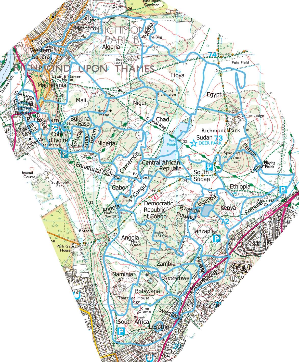
You may have noticed that the listed co-ordinates are not for Africa, but for Richmond Park. With (quite a lot of) imagination, Richmond Park is a similar shape to Africa, though a little smaller.
To find this cache you will need to complete a number of tasks, with history (and pre-history), safari (natural history) and sightseeing themes. These may be done in any order. It should be possible to complete them all in one day, but it will be quite a lot of walking even if you relocate your car for different groups of tasks. If you prefer to spread it over more than one day your phone should remember which tasks you have already completed.
You will need a smartphone such as Android, iPhone or Windows, with a GPSr and a web browser - just about every smart phone should have these. You will need to have location services enabled for the browser.
Start by visiting this web page https://www.amberel.com/africa/africa.htm and select a task - but unless you are actually in Richmond Park, you won't be able to get any further (see the Notes below).
The phone will show this outline map of where you are in Africa, with country boundaries marked. It will show where you are with a small flashing +, and will record which excursions you have completed.
The first thing you need to do for each task is to work out where in Richmond Park corresponds to the location for that task. For most of the locations you also need to research the answer to a simple question that you will have to respond to when you arrive at the location. These questions are listed on this cache page.
Once in Richmond Park, open the web page (or you can load it at home over WiFi if you prefer), select the task you wish to do first, and tap Select. The status window will show. For reliable operation, the reported accuracy should be around 15 or lower.
When you approach the location for that task (around 250 metres), an appropriate icon should appear on the screen. Walk towards the centre of this image, and when you are in the right place the status will be replaced by the question - answer the question correctly to complete the task. For a few tasks the operation is very slightly different, see the notes section below.
You may moor your superyacht:
near Cape Town at N51 25,291 W000 17.135,
on the Ivory Coast at N51 22.523 W000 17.642 or
Somalia at N51 26.222 W000 15.403.
There are airports for your private jet:
in Tanzania at N51 25.935 W000 16.112 or
in South Sudan at N51 26.387 W000 16.129.
There are refreshments in South Sudan and the Ivory Coast, and the Ivory Coast also has public conveniences and other facilities.
These are the tasks you need to perform to locate the cache.
Sightseeing
- 1) Visit the Victoria Falls. The Victoria Falls, or Mosi-oa-Tunya (Tokaleya Tonga: the Smoke that Thunders), is a waterfall in southern Africa at the border of Zambia and Zimbabwe. They are neither the highest nor widest falls in the world, but the combination of the two means they are commonly regarded as the largest. Which river they are on (one word)?
- 2) Attend the largest church in Africa. In which year was the cornerstone laid?
- 3) Climb the highest mountain in Africa. Which is the highest of the 3 volcanic cones (name of the cone, not the peak, one word)?
History
- 4) In the early 19th Century the majority of coloured people in the United States were slaves. A few had been granted manumission, but even freed slaves enjoyed only limited rights. One ship owner, a Quaker of mixed African and Native American descent, advocated settlement of freed slaves in Africa. In 1815-1816 he made a voyage with 38 emigrants, and from this grew the American Colonization Society. You need to make a note of his last name and go to where they landed.
- 5) Visit the Sphinx and the Great Pyramid. With which Pharaoh is the Great Pyramid of Giza associated (Egyptian or Greek name)?
- 6) In the 1930s Louis and Mary Leakey excavated sites in Olduvai Gorge that revealed evidence of early human evolution. Their work was built on an earlier discovery by a German paleontologist who found a human skeleton there in 1913. What was his surname? (Note: there are two German paleontologists connected with the site, I intended the more recent one but either should work).
- 7) Visit the location where Stanley met Livingstone. There is a memorial bench here, outside the enclosure and close to a tree. What is the unusual first name of the person it is dedicated to?
- 8) Visit Leptis Magna. A few of the ruins have been relocated to Virginia Water, in Windsor Great Park. What is the name of the nearest modern city to Leptis Magna (the name may sometimes be prefixed with the word Al or El, the program accepts the Al prefix or no prefix but not the El prefix)?
- 9) Visit Gondar. Climb to the top of the hill. On the plateau find the name of an explorer who, with Nikki and Max, left his mark in the year 2000.
- 10) Visit the temples at Abu Simbel. During the construction of which dam were the temples raised by 65 metres (one word)?
- 11) Visit the island where Nelson Mandela was imprisoned for 18 years. What was his Xhosa clan name?
Safari
- 12) Go to see the "surfing hippos". In which National Park will you find them (one word)?
- 13) Visit the Serengeta and Masai Mara National Parks. If you spend long enough here you should see Lion, Zebra, Giraffe, Cheetah, Ostrich, Impala and Wildebeeste. There is no question to answer - once you have seen them all the task is complete.
- 14) Zakouma National Park is a location of major importance for African elephants, but the situation is at crisis point - due mainly to Sudanese poachers, the elephant population has dwindled from 300,000 in 1970 to maybe less than 1,000 now. In which country is the park situated?
- 15) Visit the Kalahari Desert. Look for Springbok, Meerkat, Kudu, Baboon, Eland and Hartebeeste. There is no question to answer - once you have seen them all the task is complete.
- 16) Visit the Bwindi National Park to see the endangered Mountain Gorilla. What other word is in the full name of the Bwindi National Park?
Notes
The vehicle gates open at 07:00 in summer and 07:30 in winter, and CLOSE AT DUSK. Pedestrian gates are open 24 hours except during the deer cull in November and February, when they open at 07:30 and close at 20:00. If you may still be doing the cache after dark, park outside!
You can load the web page before visiting Richmond Park. The screen shows a zoomable map with your location as a flashing + cursor. If you are not in the locality, this cursor is likely to be right in a corner of the map, or maybe along one side. It should be flashing red and black alternately.
Near the cursor is a small window overlaid on the map - this is the only user interface to the web page. It has 3 modes - select task, status, and enter answer. This window may overlay a part of the map you wish to look at: if you tap the small button labelled X, the window will move to a different position. However, it should not move to a position where you cannot see it, so while the cursor is tucked into a corner tapping it will have no effect - once you get to the park it should work OK.
The select task window is used only to select the task, choose the task from the list box and tap Select. Don't stay in this mode longer than you need to, because until you tap Select, the task is not selected and you won't be able to complete it.
The status window is the one visible for most of the time. Apart from the X button, it shows your current score and the accuracy being reported by the browser location services (GPSr). The accuracy should be 15 or better, it should be around 5 most of the time as the park mostly has good GPS reception. There is a Task button that switches you to the task window if you selected the wrong task, or if you wish to change to a different task for any reason.
A task is only active when it is selected, i.e. if you go to the location of a task and it is not selected, nothing will happen. But when you get to within 250 metres of a task that IS selected, an appropriate icon appears at the task location. The status window will then display the distance to the task location. Furthermore, if you are moving, a pointer to the task location should appear. The pointer and distance are shown only when you are near the location because the main point of the cache is for you to navigate to the appropriate part of the park by yourself.
The browser does not give me access to the phone's compass. I can work out your direction only by comparing where you are with where you were a couple of seconds ago. This is why you have to be moving. The method is far less satisfactory than a proper compass. I have to filter it to reduce the jitter, and that introduces a delay in responding to a change of direction. However, it is the best I can offer and it is better than nothing.
Finally, the status window shows you the name of the current task.
When you get close to the centre of the icon, the status window is replaced by the enter answer window. You should research most of the answers beforehand, but for Gondar and Stanley / Livingstone you need to find information locally instead.
Two tasks behave quite differently - Serengeti / Masai Mara National Parks and the Kalahari Desert. At these locations you have to "find" a number of different animals. "Finding" merely means you have to go to the centre of the icon as before - but to make it more difficult these icons move around within the animal's range. But there are no questions to answer, as soon as you "find" one animal, another animal icon replaces it until you have found them all and the task is complete.
The Serengeti / Masai Mara National Parks are on a narrowish strip of land between a road and an enclosure. The animals should NEVER stray onto the road, but take care with children even so. However, they may occasionally enter the enclosure. There is a gate to the enclosure but it is some way round the side, and by the time you could get inside the animal will have gone back outside. If this happens to you, just wait a few moments - they won't stay in the enclosure for more than a few seconds.
When you have completed all the tasks, the status window will point you to the cache, which is outside the park. During this stage the distance and the pointer work wherever you are.
There are a few brambles around GZ - in summer these may be more profuse.
This is a technically complex cache, and I would appreciate feedback on how well it works for you. Even if you complete only part of the cache I am interested in your experience.
The web page is a hostage to the browser it is running in. It has been tested with an iPhone running Safari. On earlier versions of the iPhone when playing my King Arthur's Return cache, the browser sometimes forgot it was supposed to be sending location information to the page, and on these devices I found it helpful to have running in the background an app such as the Groundspeak caching app - that seemed to keep the GPS working even if the browser forgot about it. On my iPhone 6 however, the operation has been 100% faultless even without any app running in the background. I would be interested in how other browsers behave.
You can do a simple check before visiting the park by loading the page, selecting a task and tapping Select - the status display should show an accuracy of around 5-15 if you are outside and your GPS is working.
Acknowledgements: many thanks to Greg Manchester for the location icons that you will see when you get to the park.
Finally, though the questions are very easy, I am happy to confirm approximate locations and the answers before you visit, if you wish.
Enjoy ![]() .
.
 Log entries:
 3x
3x
 0x
0x
 3x
3x


