

 Please log in to see the coordinates.
 3x Found
  0x Not found
  0 notes
  0 watchers
  Rated as: n/a
 1 x recommended


 Cache attributes


 Description
EN
Description
EN
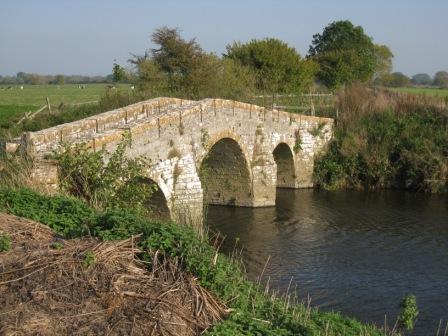
Pill Bridge - C17 Pack horse bridge. Local lias stone cut and squared. Three semi-circular arched bridge over the River Ivel, only 1.3 metres wide between high parapets; two piers on each side. First bridge recorded on this site in early C13, and represents the medieval route to Long Sutton and Langport, now an overgrown green lane. A warehouse stood nearby by 1699, and a toll house nearby (existing until 1805). It is a Scheduled Ancient Monument
A pleasant walk out to this bridge, where you may encounter deer and badger on the way, and when you get to the river, all kinds of waterfowl, and if you're lucky, kingfishers.
There is space for a couple of cars at N51 00.158, W02 41.667, but drive into Ilchester and use Pill Bridge Lane to get there. There is no access from the A303.
 Log entries:
3x
0x
0x
Log entries:
3x
0x
0x


