

 Please log in to see the coordinates.
 8x Found
  0x Not found
  2 notes
  1 watchers
  Rated as: Excellent
 1 x recommended


 Cache attributes


 Description
EN
Description
EN
This is an ex Groundspeak hide that I thought deserved to survive due to its interesting history and fantastic location, but do search considerately, as this is close to an archaeological area.
Harry's Cache, St Mary's, Isles of Scilly was hidden on Friday 6th September 2002.
https://www.geocaching.com/geocache/GC8B81_harrys-cache-st-marys-isles-of-scilly
It was hidden by Allan & Susan (Stonehunters) in memory of Susan's late father, "who loved the islands".
Their description says, "This cache is at the top end of St. Mary’s which often goes unvisited. However, as we discovered it is a very interesting area with splendid antiquities and views. Please note that the cache is definitely not hidden amongst the archaeological site and therefore do not, under any circumstances, disturb the location. Please use your GPS to locate. The cache is a small, yellow topped plastic container, holding logbook, pencil, jewellery and other items."
Unfortunately they no longer use the website so I can't tell them that I have revived their hide.
The cache was archived, unfound, in April 2003 in a log that says that the coordinates are wrong but they are, in fact, exactly right.
My attention was drawn to this cache by one of heartradio's lists but I never thought to look for it. Then, on 19th May 2019, the cache FTF was made by canalcruisers after 6100 days or 16 years, 8 months, 14 days or 200 months, 14 days. On 8th August 2019 I went to look for the cache and, just like canalcruisers, I found it straightaway and in very good condition. I couldn't log my find as the cache page was "locked" by Groundspeak after the FTF log.
As the original description says, this cache is hidden close to the Iron Age Village on Halangy Down. This is a scheduled ancient monument, managed by English Heritage, with free, 24 hour, open access. (Though I suggest only searching in daylight.)
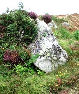
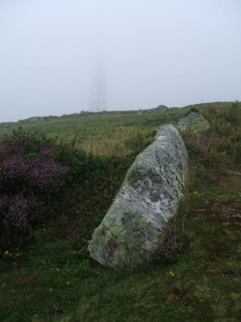
The cache is hidden under the lower left hand corner of a large rock.
There is no need to disturb any flora or rocks in order to find it and it is very easy to spot.
If you can't immediately see the cache then you have the wrong rock. I have included both the original and my own spoiler images so that there is no ambiguity about the location in this sensitive area. Note the mast in the gloomy background of my photo and that will help to confirm the location.
Please take care not to damage any of the village, although visitors are free to wander among its remains.
You can read more about the history of the site in various places. There is a nearby, much older Bronze Age tomb and the site is interesting because in the past it would have looked out not over the sea between the islands but over land between them that was inundated by rising sea levels in the last 10000 years or so.
https://www.megalithic.co.uk/article.php?sid=6333313
https://www.themodernantiquarian.com/site/2654/halangy_down.html
I hope the cache survives another 17 years.
Other new ancient ones:
- Hell Bay, originally hidden by Street Pilot on 24th August 2001: https://opencache.uk/viewcache.php?cacheid=905 https://www.geocaching.com/geocache/GC1B1D_hell-bay
- Harry's Cache, originally hidden by by Allan & Susan (Stonehunters) in memory of Susan's late father, "who loved the islands" on Friday 6th September 2002: https://opencache.uk/viewcache.php?cacheid=1223 https://www.geocaching.com/geocache/GC8B81_harrys-cache-st-marys-isles-of-scilly (Sadly, now locked as well as archived)
- Birdman's Cottage on Bryher: hidden by NoPuffin on 5th April 2005 https://opencache.uk/viewcache.php?cacheid=1256 https://www.geocaching.com/geocache/GCNC24_birdmans-cottage
- Harry's Wall: hidden by Street Pilot on 29th August 2001. https://opencache.uk/editdesc.php?descid=1264 https://www.geocaching.com/geocache/GC1B27_harrys-wall
 Additional hints
 Pictures
 Log entries:
8x
0x
2x
Log entries:
8x
0x
2x


